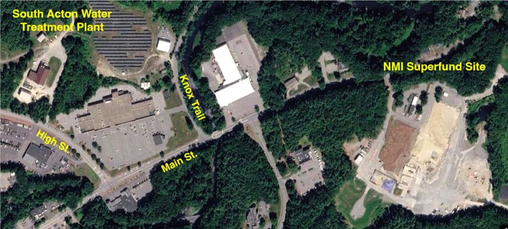
At an evening meeting on April 2 held virtually and at Concord Town House, the U.S. Environmental Protection Agency’s (EPA) Remedial Project Manager Kara Nierenberg, EPA’s community involvement coordinator Charlotte Gray, and the de maximis project coordinator Bruce Thompson, provided a 90-minute progress update on the Nuclear Metals Inc. (NMI) Superfund Site to residents of Concord and Acton. This Superfund site is located in the southwest corner of Concord, near the Acton town line.
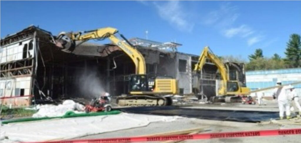
The April 2 meeting was the most recent in a series of project updates on the site restoration and groundwater contaminant remediation since the EPA’s initial involvement in 2001. It was reported that all of the buildings on the property have now been completely dismantled and removed from the site, along with hazardous infrastructure components that included numerous pipes containing asbestos. The site restoration is progressing as planned, and the town of Concord is currently exploring the potential reuse of this property for recreation or housing.
Acton’s interest in this superfund project is primarily focused on the potential harm caused by the migration of the depleted uranium (DU) and 1,4-dioxane groundwater plumes that are being drawn from the NMI property, underneath the Assabet River, and towards the Assabet public water supply wells in South Acton. The Acton Water District (AWD) currently has three wells connected to the South Acton Water Treatment Plant that are situated less than a half mile from the Nuclear Metals (NMI) site. Well outputs vary depending on operational constraints, but on a typical day this treatment plant provides approximately 70% of the Town’s water supply. The importance of this resource is clear, and it is essential that these wells remain in compliance with all state and federal water quality regulations.
History of the NMI Superfund Site
Mr. Thompson introduced himself as the project coordinator for de maximus, inc., the contractor carrying out the remediation work at the NMI site. He began his presentation with an overview of the history of the Nuclear Metals facility and the subsequent evolution of the superfund project under the management of the EPA. The materials processing work performed by Nuclear Metals dates back to the late 1950s, and was an outgrowth of research performed by MIT during the development of the first atomic bomb. The company specialized in exotic materials such as depleted uranium and beryllium, which were used for a variety of military programs. Depleted uranium is a byproduct of a process that extracts the highly radioactive isotopes from naturally occurring uranium that are essential for the construction of nuclear reactors and weapons. Since the density of DU is twice that of lead, it has been used by the military to make tank shells that are capable of piercing-heavily armored vehicles. This material is only weakly radioactive, but its presence in water represents a serious health concern because it is a highly toxic heavy metal. An additional health concern is the chemical 1,4-dioxane, which was used during NMI’s manufacturing process as a solvent and stabilizer. While the migration of uranium through the soil is relatively slow, 1,4-dioxane is more mobile and represents a more significant risk to the water resources in South Acton. The production of depleted uranium penetrators ended in 1997, and at that time the name of the company was changed to the Starmet Corporation. The site was placed on the National Priorities List in 2001, and the EPA began removing hazardous materials from the property in 2002. The EPA finally took control of the facility in 2011 after it had been abandoned by Starmet. Demolition of the buildings and associated infrastructure on the 46-acre property was initiated by EPA contractors in 2011, and subsequently completed in 2016.
Site Restoration
Ms. Nierenberg then explained that the EPA has established two primary goals for the restoration of the NMI Superfund Site. The first of these goals is the removal and stabilization of all hazardous materials from the property so that the land can eventually be reused for recreation or residential housing. The second goal is the remediation of the contaminant plumes that threaten the Acton Water District’s wells in South Acton. Each of these tasks involves a complex set of engineering solutions that will require several more years to complete.
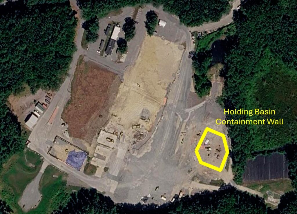
The stabilization of the contaminated soil in the holding basin situated at the southeast edge of the superfund site represents a particularly difficult aspect of the site restoration problem. Between 1958 and 1985 this unlined basin was used for the disposal of waste products such as depleted uranium, nitric acid, and copper. The uranium deposits are especially problematic because they are too deep to be easily extracted. To address this situation, an in-situ sequestration approach has been developed that involves deep injections of microscale zero-valent iron into the holding basin. The iron injections are being performed at approximately 100 densely-packed locations within the confines of the basin, which should stabilize the uranium and prevent the migration of the metal through the soil. To further contain this material, the basin will be surrounded by a 3-foot-wide concrete enclosure that will extend down to the bedrock at a depth of 90 feet. This enclosure will be capped when completed. Contaminated soil outside of the holding basin will be excavated to a depth of 10 feet and moved off site for disposal at an approved location.
Groundwater contaminant remediation
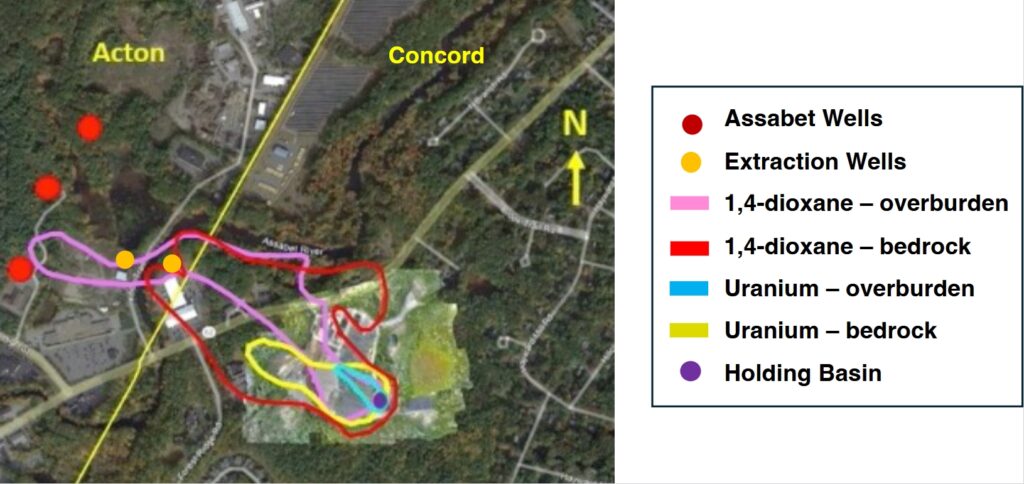
As noted earlier, a variety of hazardous materials were deposited into the NMI holding basin starting in the late 1950s. As a result of the short distance between the AWD’s Assabet wells and NMI contamination source and the high-volume water extraction from those wells, trace amounts of both uranium and 1,4-dioxane have steadily migrated westward. As the figure below illustrates, the 1,4-dioxane plume extends much closer to the well field than the uranium plume and is the primary focus of EPA’s remediation effort. This contaminant moves through the overburden (soil, sand, silt and clay) close to the surface and through cracks in the bedrock below. The primary remediation approach employed by the EPA involves the placement of multiple extraction wells in both the overburden and bedrock to intercept the dioxane plume before it can reach Acton’s drinking water wells. (Two of the overburden extraction wells are shown in the illustration.) All of the water produced by the extraction wells is piped to a central treatment facility located on Knox Road in Acton and then discharged into the Assabet River.
Sampling data from the Assabet wells and the extraction wells appears to verify that this remediation approach has been effective. The following graph shows historical measurements of 1,4-dioxane concentrations from the AWD’s Assabet 1A well and the EW-1 extraction well. These data demonstrate that contaminant levels have dropped by about a factor of two since the extraction well began operation in 2016. Since that time, measured 1,4-dioxane concentrations at Acton’s wells have been well below the EPA health advisory level. These measurements are being carefully monitored by the Acton Water District.
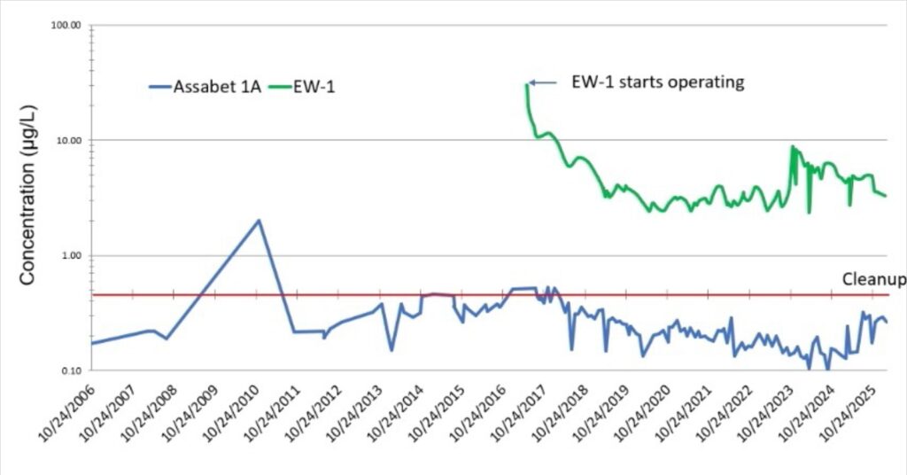
The Acton Exchange invited the Acton Water District to comment on the Superfund groundwater remediation effort. District Manager Matthew Mostoller replied by email: “We appreciate the sustained efforts and interventions undertaken by MassDEP [the Massachusetts Department of Environmental Protection], USEPA, and NMI since 2017 to address environmental contamination in the vicinity of Acton’s Assabet wellfield, the largest source of public water supply for the town. Significant changes in our pumping strategy in response to PFAS [per and polyfluoroalkyl substances] concerns, including reduced yield from the Assabet 1A well and a shift in pumping activity toward the north and east, have altered groundwater flow dynamics in ways that require further evaluation to fully assess the effectiveness of these earlier interventions. We remain committed to continued collaboration with regulatory agencies and stakeholders to better understand these changes and to ensure that future actions are informed, adaptive, and protective of both public health and water resources.”
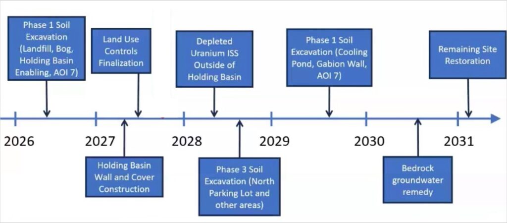
Timeline for the remaining work at the Nuclear Metals superfund site
Ms. Nierenberg expressed confidence that the site would be ready for reuse as scheduled in 2031. Following that date, the status of the site remediation will be reviewed every five years. Remediation of the groundwater will continue even after site reuse has begun.
Ms. Nierenberg concluded the meeting by expressing her thanks to the community groups that have been involved in the remediation process. These groups include Concord Research and Environmental Watch (CREW), Green Acton, the 2229 Main Street Oversight Committee, the 2229 Main Street Advisory Task Force, and the NMI/Starmet Re-use Planning Committee.
Dr. Parenti is a member of the Town of Acton Water Resources Advisory Committee.